From Raw LiDAR Data to 3D Mapping: A Practical Workflow
Introduction
LiDAR technology has become an important part of modern surveying and mapping. It allows us to collect highly accurate three-dimensional information about the ground, buildings, roads, vegetation, powerlines and other objects.
However, collecting LiDAR data is only the beginning. The real value comes from processing the raw point cloud and converting it into accurate, usable mapping data.
This article explains a practical workflow from raw LiDAR data to final 3D mapping.
1. Raw LiDAR Data Preparation
The first step is to import and organize the raw LiDAR data received from the survey. Depending on the project, the data may contain millions or billions of individual points.
The initial checks normally include:
• Coordinate system and projection
• Point cloud coverage
• Data completeness
• Flight or survey gaps
• Point density
• Accuracy and quality checks
Proper data preparation is important because errors at this stage can affect the entire mapping process.
2. Point Cloud Classification
After quality checking, the point cloud is classified into different categories.
Typical classifications include:
• Ground
• Vegetation
• Buildings
• Roads
• Powerlines
• Poles and other structures
• Water or other project-specific features
Ground classification is particularly important because it helps create an accurate representation of the terrain.
Automated classification tools can speed up the process, but manual checking and editing are often required to achieve the required accuracy.
3. Practical Example: Powerline Mapping
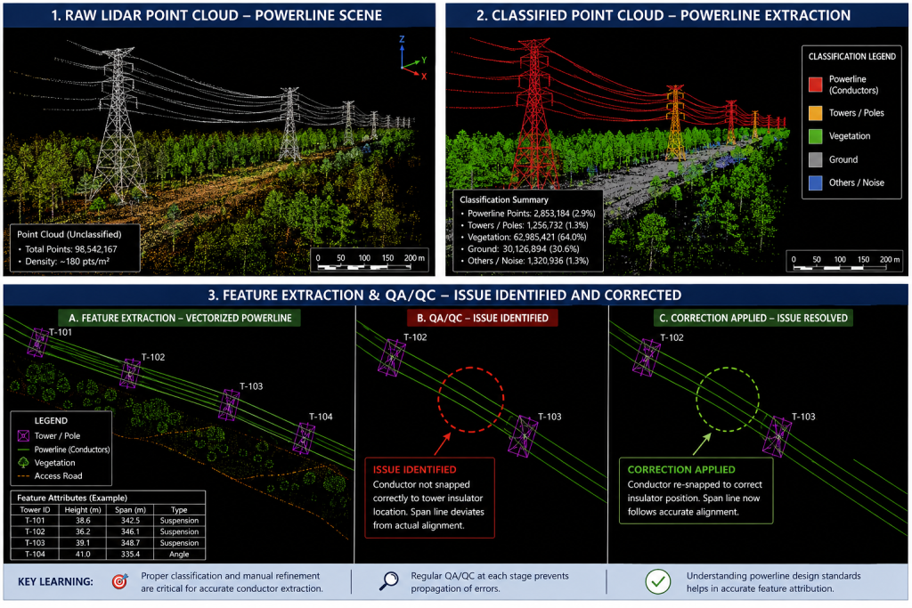
A practical example of this workflow is powerline mapping from LiDAR data. In a powerline project, the objective is to identify conductors, poles and nearby vegetation and convert them into accurate 3D mapping features.
During classification and feature extraction, the main challenge can be separating thin powerline conductors from surrounding vegetation and other elevated objects. Automated classification can help identify likely conductor points, but these results need to be checked against the point cloud manually.
During QC, a mapping error can be identified when a conductor is incorrectly classified, interrupted, or connected to an unrelated object. The point cloud is reviewed from suitable viewing angles, the incorrect classification or extracted line is corrected, and the feature is checked again against the surrounding points.
This process highlights an important lesson: automated tools improve efficiency, but experienced manual checking is still important for thin and complex features such as powerlines. Careful QC helps ensure that the final 3D linework represents the actual feature and follows the project specifications.
Illustrative figures can be placed alongside this workflow to show the point-cloud/classification view and the resulting extracted powerline features.
4. Feature Extraction
Once the point cloud has been classified, relevant features can be extracted.
For example, in a road-mapping project, the workflow may involve identifying road edges, road surfaces, kerbs, drainage features, signs, poles, buildings and other nearby structures.
For powerline projects, conductors, poles and vegetation around the corridor may need to be identified and mapped.
Feature extraction converts the information contained in the point cloud into useful mapping features.
5. Creating 3D Mapping Data
The extracted features can then be converted into 3D vector data using CAD or GIS software.
Depending on project requirements, the final deliverables may include:
• 3D polylines
• Points
• Polygons
• Digital Terrain Models (DTM)
• Digital Surface Models (DSM)
• Contours
• Building footprints
• Utility networks
The correct coordinate system, elevation information and project specifications must be maintained throughout the process.
6. Quality Control
Quality control is one of the most important stages of LiDAR mapping.
The final data should be checked against the point cloud to ensure that:
• Features have been correctly identified
• Lines and points are accurately positioned
• Elevations are correct
• No important features are missing
• Classification is consistent
• The final data follows project specifications
A good QC process helps identify mistakes before the final delivery.
7. Final Deliverables
After processing and quality control, the final mapping data can be delivered according to the client’s requirements.
Common formats include CAD and GIS-based deliverables, along with point cloud, terrain and surface models where required.
The final objective is not simply to produce a point cloud, but to transform complex LiDAR information into accurate, structured and usable 3D mapping data.
Conclusion
The journey from raw LiDAR data to 3D mapping involves several important stages: data preparation, classification, feature extraction, 3D mapping and quality control.
A well-organized workflow improves both accuracy and efficiency and allows LiDAR data to be effectively used for applications such as road mapping, utility mapping, infrastructure development, surveying and digital terrain analysis.
With the right combination of automated processing, skilled editing and quality control, raw LiDAR data can be transformed into reliable 3D information that supports real-world engineering and mapping projects.