Beyond the Camera: How Drones Are Being Used for Industrial Data Collection
When most people picture a drone on the job, they picture a camera. Footage of a construction site. A real estate flyover. Maybe a cinematic shot for social media. That image isn’t wrong exactly, it’s just stuck about ten years in the past. In the industries that have quietly built serious drone programs, the camera is often an afterthought. The sensor doing the real work is something else entirely.
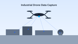
What those operators actually want is data. Not images. Not video. Structured, repeatable, sensor-driven information that feeds into engineering reports, maintenance schedules, and planning decisions. The drone is just the thing that carries the sensor to the right spot safely and repeatedly. Once you start thinking about it that way, the range of what these platforms can actually do gets a lot more interesting.
From Photos to Purposeful Data
A photograph tells you what something looks like. It doesn’t tell you how thick a pipe wall is, how much ore is sitting in a stockpile, whether a transformer is running hotter than it should, or how much the vegetation on a slope has changed since last spring. Those questions need sensors, not cameras, and they need a processing pipeline that turns raw readings into something a site manager or engineer can actually act on.
That’s what serious industrial drone programs are built around. Each mission starts with a data objective. The sensor payload gets matched to that objective. The flight plan gets designed around coverage requirements and accuracy targets. And the output goes somewhere useful, into a GIS platform, an asset management system, a structural report, or a client deliverable that’s ready to use without additional interpretation.
The Sensors Doing the Heavy Lifting
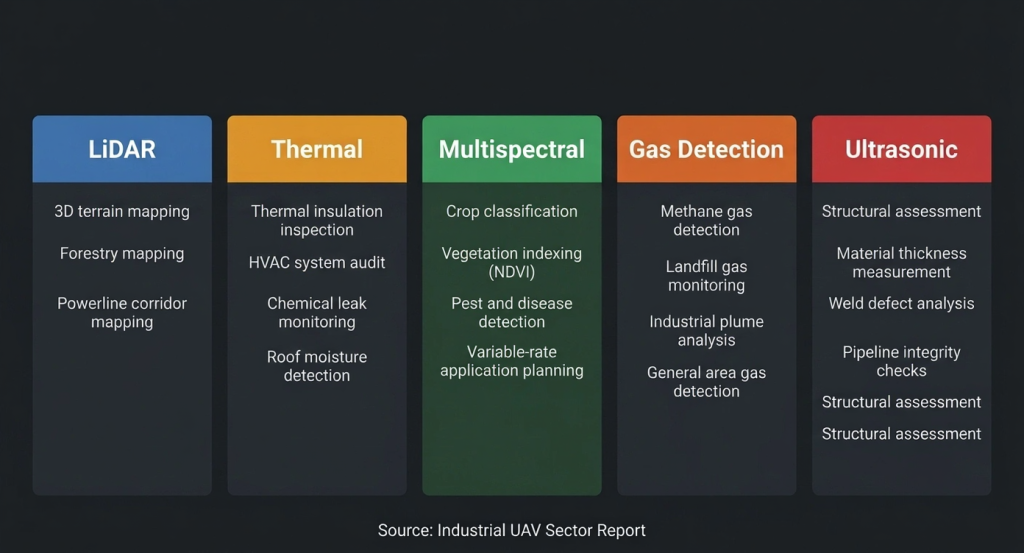
LiDAR is probably the most widely used industrial payload. It fires laser pulses and measures the return time to build a dense three-dimensional point cloud. Miners use it to calculate stockpile volumes. Civil engineers use it to generate terrain models for earthwork design. On forested sites, it can map the actual ground surface beneath tree canopy, something standard cameras can’t do at all.
Thermal imaging reads heat. Every surface emits infrared radiation, and a good thermal sensor turns that into a visual record of temperature variation. Power utilities use thermal drones to find hotspots in electrical infrastructure before they become failures. Pipeline operators use them to detect leaks through temperature differentials that are invisible to the naked eye. Construction teams use them to find moisture intrusion and insulation gaps in buildings.
Multispectral sensors pick up light beyond what the human eye can see. Agriculture has adopted them heavily because crop stress, irrigation problems, and early disease show up in near-infrared and red-edge wavelengths long before you’d notice anything walking the field. The same technology works for environmental monitoring: tracking land cover change, mapping wetland health, assessing post-fire recovery.
Gas detection payloads let drones go into places that are genuinely dangerous for people. Methane sensors can sweep pipeline corridors and landfill sites for emission leaks. Hydrogen sulfide detection matters in refineries and wastewater plants. Sending a drone into those environments instead of a person is not just cheaper, it’s the right call.
Ultrasonic sensors are newer to the drone world but increasingly practical. They measure wall thickness on structures like storage tanks and bridge components, the kind of corrosion assessment that used to require scaffolding, rope access teams, or confined space entry. Drone-mounted contact sensors are cutting setup time and keeping inspectors out of hazardous positions on more of these jobs every year.
Who’s Actually Using This
Oil and gas was an early adopter for reasons that make sense. The assets are enormous, the inspection costs are high, and the safety risk of traditional methods is real. Thermal and visual drone inspections of pipelines, tanks, flare stacks, and offshore platforms have become routine on well-run operations. Inspection cycles that once required shutdowns or rope access crews now run continuously during normal operations.
Utilities are using drones to monitor transmission lines, substations, wind turbine blades, and distribution networks at a frequency and scale that helicopter patrols never could have matched economically. A single flight can cover dozens of kilometers of corridor, flagging vegetation encroachment, hardware defects, and insulator problems with enough detail to replace a significant portion of conventional inspection work.
Construction and land development need current spatial data at every project phase. Before ground is broken, drones establish the topographic baseline that earthwork plans are built from. During construction, repeat flights catch discrepancies against design models while there’s still time to correct them. For boundary mapping, grading verification, and as-built documentation, drone land survey workflows using RTK-GPS positioning deliver survey-grade outputs that stand up in both engineering review and legal documentation.
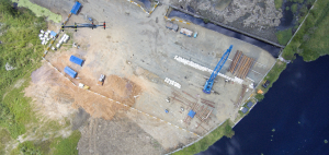 Construction site surveyed using aerial photogrammetry.
Mining uses drone LiDAR and photogrammetry for stockpile measurement, pit mapping, and haul road assessment. Getting an accurate stockpile volume used to take a survey crew half a day and keep equipment idle. A drone does it in an hour while the site keeps running, and the numbers feed directly into inventory accounting.
Agriculture at commercial scale has a data demand that ground scouting can’t meet. Multispectral flights identify plant stress, irrigation gaps, and pest pressure early enough to treat targeted areas rather than broadcasting inputs across entire fields. That specificity reduces cost and often improves yield at the same time.
Getting the Data Into the Right Systems
The value of collected data depends entirely on where it ends up. Industrial drone programs that actually stick are built around pipelines, not just flights. Processed outputs go into GIS platforms as orthomosaic maps and vector layers. Digital twin systems ingest drone data as a regular reality capture layer to keep models current. SCADA and asset management platforms receive anomaly reports that trigger maintenance work orders automatically.
Standard output formats handle most integration needs: LAS for point clouds, GeoTIFF for orthomosaics, shapefiles or DXF for vector data. These slot into AutoCAD, ArcGIS, Bentley, and similar platforms without much conversion friction. The goal is that a processed drone dataset lands in the engineer’s software ready to use, not ready to be re-processed.
The Case for Drone-as-a-Service
Most industrial operators don’t need to own drones. They need data on a schedule, processed to a standard, and delivered in a usable format. Drone as a Service (DaaS) is the model that fits that requirement. The provider handles the aircraft, the pilots, the certifications, the airspace authorizations, the sensor payloads, and the processing. The client gets finished datasets without managing any of the operational complexity behind them.
For industrial buyers the math usually works in favor of contracting over ownership. Hardware depreciates fast in a sector where sensors and platforms improve every couple of years. Pilot certifications and airspace approvals take time and expertise to maintain across different jurisdictions. Specialist payloads, a gas detection sensor used twice a year for pipeline inspection, for example, are rarely worth owning outright. Pay-per-mission or subscription structures let organizations spend in proportion to what they actually need.
DaaS also scales geographically in ways that owned fleets don’t. A contracted provider can mobilize across multiple sites in different countries, managing local regulatory requirements for each one, without the client needing to build internal compliance capacity in every market.
Accuracy and Compliance
Industrial data collection has no tolerance for approximate results. Engineering decisions, legal records, and asset management systems depend on data that meets defined standards. RTK-GPS combined with ground control points placed at known coordinates on the survey area routinely delivers horizontal and vertical accuracy within two to three centimeters on well-controlled sites. That’s survey-grade performance, comparable to total station and GNSS methods, but faster and usually at lower cost.
Regulatory compliance matters just as much as technical accuracy. BVLOS approvals, controlled airspace authorizations, and commercial pilot certification requirements vary by country and operation type. Established DaaS providers manage this as part of the service, which matters because data collected without proper authorization isn’t just a legal risk. It’s potentially inadmissible in any context where the collection process gets scrutinized.
Where This Is Heading
Autonomous repeat missions are already running in mining, utilities, and large-scale agriculture. The same flight path, executed on a schedule, without manual pilot input per flight. What this produces is a longitudinal dataset: the same site under comparable conditions at regular intervals. Change detection across those datasets reveals trends that a single survey never could.
AI anomaly detection is beginning to handle the interpretation workload. Instead of an analyst reviewing thousands of thermal or LiDAR frames, models flag statistically significant deviations from baseline, delivering a prioritized list of issues rather than a data volume problem. For organizations managing hundreds of inspection points across large asset bases, this is moving from pilot project to standard practice.
The natural destination for all of this is the digital twin. As drone data collection gets more frequent and more automated, the gap between physical asset and digital model narrows. Eventually the twin isn’t a quarterly update. It’s a live, inspectable representation of what the asset looks like today, useful for predictive maintenance, operational planning, and remote oversight in ways that periodic inspection programs alone have never been able to support.
The camera was always just the starting point.
Interested in industrial drone operations?
Explore our growing Knowledge Hub or connect with professional drone operators through Drone by Nature.